Our new map series index, Southwest Germany to the Alps, is now available to the public in this interactive web map.
The Southwest Germany to the Alps map series index is an interactive web map that displays the topographic features and municipalities of Southwest Germany and its surrounding countries.
- Geographic Coverage: Southwestern Germany, and portions of its surrounding countries
(Belgium, Luxembourg, Switzerland, Austria, Czechia, France), up to the Alps - Time Range: 1867 series with supplements ranging from 1904 to 1951
- Physical Availability: In-house use only
- Digital Availability: Scanned (600dpi)
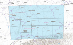
This map series index contains 25 sheets at a scale of 1:250,000 and arranged as a 5x5 grid covering Southwestern Germany to the Alps, as well as portions of neighboring countries. Originally published in 1867, several of the sheets of this series were updated with new geographical data from 1904 to 1951. This series showcases topographic data as well as significant municipalities at the time of each sheet’s publication, such as Stuttgart, Zurich, Munich, and many more.
When all the sheets of this series are arranged physically, the size of the map would be approximately 24 feet by 17 feet, so this interactive index provides an easier way to access the array of information on these maps.
The maps of this index are situated over a contemporary basemap, allowing the viewer to orient the maps amongst modern geographical features and view a variety of related data including satellite imagery, streets, and topography.
We hope you enjoy exploring this series and learning more about Southwestern Germany and its neighboring countries. If you would like to view our maps in person or access the high resolution scans of any of these maps, please submit a Service Request including the map’s name and year as found in the map’s pop-up box and our staff will prepare the requested map(s) for viewing. Be sure to visit our Facebook page for all the latest Map and Geospatial Hub updates!
-Giovanni Catanzaro – Map and GIS Assistant