Germany news

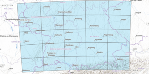
A 5x5 rectangular grid over southwest Germany, showing the extent of the new map collection.

New Map Collection and Index: Southwest Germany to the Alps

The index for our new map series index, Southwest Germany to the Alps, is now available to the public in this interactive web map. The Southwest Germany to the Alps map series index is an interactive web map that displays the topographic features and municipalities of ...

Map of Europe and the Union of Soviet Socialist Republic. Boundaries between countries featured, which include Ireland, England, France, German, Poland, Czechoslovakia, Denmark, Netherlands, Lithuania, are variably colored. Country names are black and bolded while town names densely cover the interior.

Map of the Month: August 2021

  Our August Map of the Month is this National Geographic map titled Europe and the Near East. It displays a comprehensive post-WWII view of Western and Eastern Europe as well as the North African Coast and part of the Middle East. Published in 1949 after the conclusion of several years of negotiat...