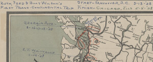
In the ASU Library we strongly discourage people from writing on library materials. However, occasionally we come across annotations that give a glimpse of the past.

Prior to coming into our possession, this Road Map of the United States was used by Ruth, Fred, and Billy Wilson to guide them on their “First Trans-Continental Trip” in 1928. This is most likely the same Fred Wilson whose photographs and papers are in the ASU Library’s Arizona Collection.
The family took extensive notes on the map. The trip started on March 18 in Vancouver and finished on May 5 in Chicago. All along the way are notes about where the family spent the night, road conditions, places they visited, and where they ate lunch.

Of particular note are the nine Harvey Houses they ate at and stayed in as they crossed Arizona, New Mexico, Colorado, and Kansas. Harvey Houses were lunch rooms, restaurants, and hotels along the Atchison Topeka and Santa Fe railway. Starting in 1876, Fred Harvey created these establishments to provide good food at a reasonable rate for railway travelers. Harvey House hotels, such as the El Tovar at the Grand Canyon which the Wilson family visited, also catered to the reasonably well off tourist with money to spend on excursions and Native American crafts.
It appears that a few years after this trip, Fred Wilson moved to Phoenix and later purchased Vaughn’s Indian Store renaming it Fred Wilson’s Indian Trading Post. Wilson operated a chain of trading posts throughout the southwest. Perhaps it was this 1928 trip that inspired this business venture.
by Karina Wilhelm, Map Specialist

