The Grand Canyon is one of the modern natural wonders of the world. It’s been mapped countless times over the years, and is the second most visited national park in the United States. However, the mapping history of the Grand Canyon is relatively young; the first USGS quadrangle maps of the Canyon weren’t published until 1906, after being surveyed by Francois E. Matthes and Richard T. Evans during 1902-03. This survey would continue until 1923, taking 21 years to map out the portion of the Grand Canyon that would turn into a National Park.. One of the most famous USGS Topo maps came from this survey: the Bright Angel Quadrangle. September’s Map of the Month is an exceedingly rare advanced sheet of the Bright Angel Quadrangle, one of the preliminary copies made before the final product was sent to the presses.


This quadrangle contains the area that the vast majority of visitors to the Canyon experience, as the Grand Canyon Village is almost exactly in the center of this map’s portion of the south rim. The exact date of creation is unknown, but we know it predates 1906 and possibly 1905, as the Grand Canyon Village isn’t as developed as it will appear on the original 1906 production. Most notably the structure for the El Tovar Hotel is missing, as is the small road loop that leads up to it.
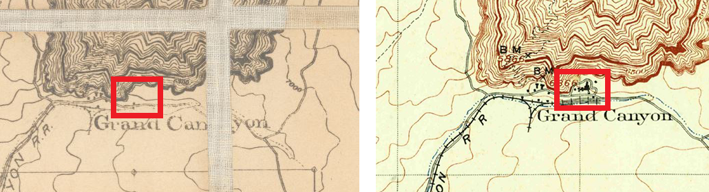
Additionally, the advance sheet is notably less detailed in a majority of the Canyon’s steep walls, as can be seen here:

A majority of the contour lines are missing, and others that remain are disconnected and unfinished. Even more interesting still is how small portions of this area have been fully detailed, supporting the idea that the cartographers were still in the process of drawing the map and created this copy to test how it looked before continuing with their work.
Interestingly enough, the cartographers also drew more detail than would be maintained in the production version, as the contours and canyons of this advance sheet advance beyond the boundaries of the quadrangle. One can only guess, but it’s likely that we’re seeing the full extent of the survey and the removed data would be seen in adjacent quadrangles once they were completed.

We hope you enjoyed this month's map! The full survey of the Grand Canyon done by Matthes and Evans between 1902-1923 and published in 1927 can be explored in a web application that overlays it on the modern-day National Park.
As with all of our Map of the Month features, if you’d like to learn more about this map or schedule a visit to explore our maps in person, please submit a Map and Geo Service Request. We’ll be sure to get back to you within two business days, but typically sooner.
- Eric Friesenhan, Map and GIS Specialist