Our November Map of the Month is this 1919 British War Office map titled “Map of Africa to Illustrate the Progress of Surveys and Explorations”. Originally published in 1914 and updated in this edition, it depicts the entirety of the African continent with data on the topographic surveys that had been conducted in each region prior to the date of publication.

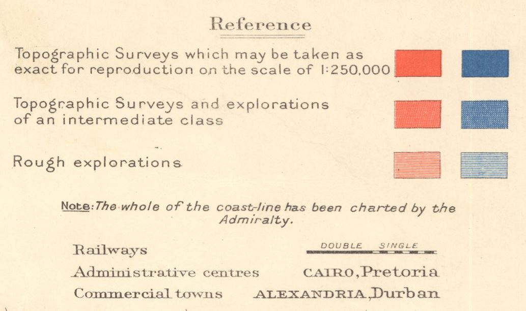
This map appears to denote separate survey expeditions by color, though there are no notes to identify the surveys’ names, dates, or other details. The red shading seems to show surveys conducted on land that was under the control of Great Britain while the blue indicates surveys conducted on non-British holdings. Beyond this distinction by color, there are also three types of shading that indicate different levels of survey comprehensiveness in a given region. As explained in the map’s key, the most solidly colored areas indicate the most accurate and comprehensive topographic surveys while the lightest areas indicate “rough explorations” and presumably far less accuracy and detail. Although on the surface this map depicts cursory information about topographic knowledge in 1919, the reasons and methods of these surveys often coincide with significant points in the history of African Imperialism.
Many European nations had maintained a colonial presence in Africa to some degree by the time of this map’s publication, but the process of officially surveying the land was a relatively recent development in the 1910s. Many of the earliest European “surveys” were informal and conducted on private expeditions that focused on things like botany and available resources. It was not until the late 1800s that nations like Great Britain realized how limited their comprehensive knowledge of African land was, which in turn led to more survey expeditions like those documented on this map. This increased interest in improving African cartography contributed to the expansion of European knowledge of the continent which in turn led to a greater interest in possessing African territory and resources. This interest was directly responsible for events like the Scramble for Africa at the 1884 Berlin Conference, which caused the development of countless socio-political issues throughout Africa.

The areas of this map that denote the most comprehensive and accurate topographic surveys frequently coincide with the regions that historically experienced a greater deal of interaction with and occupation by European nations and explorers. In addition to Great Britain, France had one of the largest colonial presences in Africa, particularly in the north. Northern Algeria and Morocco were occupied by France from the early 1800s onward, so by the 1910s there was almost a century’s worth of colonial knowledge of the region. It is likely that French colonial leaders had conducted surveys of the region prior to the British push for surveying Africa in the late 1800s, contributing to the extensive topographic knowledge that had been collected by the 1910s.

One region that the British had a similarly long presence in was southern Africa. In the 1910s, Great Britain still held the territories of modern South Africa as well as much of the surrounding territory, which again appears to have enabled them to conduct some of their most comprehensive topographic surveys on that region. A great deal of British topographic knowledge was collected by the War Office during the Boer Wars, wherein the South African Republic Boers revolted against the British and made several attempts to oust them from the territory that were ultimately unsuccessful. In response to their loss in the First Boer War, the British worked to increase their knowledge of the region and develop a strategic upper-hand before engaging in the Second Boer War which they went on to win. The knowledge collected during the Boer Wars probably made up a large portion of the comprehensive surveys indicated on this map.

One of the most infamous regions of Imperial Africa was Central Africa and the Belgian Congo in particular. This region was renowned for its remote and mysterious qualities that were frequently romanticized by European nations, its vast natural resources including many precious metals, and eventually the atrocities committed by European colonizers against the region’s native peoples. The Congo’s thick jungles often made exploration difficult for colonists, which likely explains why the region as shown on this map has several unexplored areas and frequent differences in survey detail. However, the value of the land and its resources encouraged Europeans to maintain their efforts of imperialism in the region, which explains why most of the land was given at least a “rough exploration”.

We hope you enjoyed this month's map! As with all of our Map of the Month features, if you’d like to learn more about this map or schedule a visit to explore our maps in person, please submit a Map and Geo Service Request. We’ll be sure to get back to you within two business days, but typically sooner.
- Kelsey Kerley, Map and GIS Assistant