The United States National Park Service (NPS) currently administers 63 National Parks and 85 National Monuments, among the astonishing 423 total areas managed by the agency. That scope wasn’t always so large. In the years after its 1916 inception, the NPS oversaw only a small fraction of the national park and monument units that it oversees today.
This month, we’re showcasing this early form of the National Park Service with a map titled National Parks and Monuments in the United States. The map is undated.
It’s not terribly uncommon to encounter an undated map here at the Map and Geospatial Hub. In these cases, we typically scrutinize the geographical information on the map to determine, at least roughly, when the map was published, at least within a couple years or so.
As I began to study the map, I found myself headed deeper and deeper into a bit of a rabbit hole of sorts. There are inconsistencies between the parks and monuments listed on the map with and the well-documented official dates of those units’ founding or renaming.
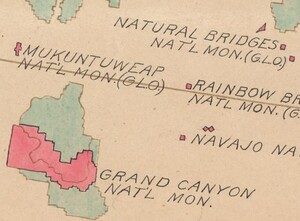
The first step to reconciling these discrepancies is typically to establish a definitive date associated with the appearance of one or more map features. In this case, I noted the presence of the Grand Canyon and Mukuntuweap (now known as Zion) National Monuments.

The Grand Canyon was first designated as the Grand Canyon “Game Preserve” by President Theodore Roosevelt in 1906. Designation as a National Monument came two years later, in 1908. Grand Canyon wouldn’t gain status as a National Park until February of 1919 with the passage and signing of the Grand Canyon National Park Act.
Separately, just north of the Grand Canyon in southwest Utah, we find Mukuntuweap National Monument. Mukuntuweap was renamed to Zion in March of 1918. The presence of these two units on the map, Grand Canyon and Mukutuweap, puts our date somewhere prior to March 1918.
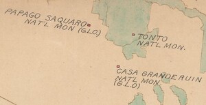
As we move to other features on the map, we see Casa Grande Ruin National Monument in south-central Arizona, established in August 1918. But, recall that, based on the features described above, the map appeared to be published before March 1918. Our investigation is now less clear cut than we thought.
If the map was published after Casa Grande Ruin was established, Mukuntuweap should then be labeled as Zion. To further complicate matters, the Capulin Volcano National Monument, located in northeastern New Mexico and established in 1916, is missing from the map entirely. There are also two National Parks missing: Hawai’i Volcanoes, founded in 1916, and Denali National Park, established in 1917.
To make matters even more contradictory and confusing, the map also includes a feature for Hot Springs Res. National Park in Arkansas. That’s another anachronism, as this unit officially became a national park in 1921 — three years after our supposed date of 1918. The reality is that the federal government designated the area as “Hot Springs Reservation” in 1832, far before the 1916 creation of the NPS.
However, in 1916, the reservation fell under the administration of the NPS. That likely explains why it’s listed as a National Park on this map. This, aside from the inconsistencies listed above, point to a general publication time of late 1918! It’s entirely possible the author simply wasn’t aware of those parks and monuments, though the true explanation will likely never be fully known.

If you are interested in seeing more of this map you can view it online in a dedicated web mapping application hosted on ASU Geodata. In that web map, this digitized national park map has been overlaid across a modern map of the world, spatially referencing it to ground the data to real world locations. The info on the map has been digitized and expanded on, providing more insight into the park units and comparing it to the modern NPS system.
We hope you enjoyed this month's map! As with all of our Map of the Month features, if you’d like to learn more about this map or schedule a visit to explore our maps in person, please submit a Map/Geo Service Request. We’ll be sure to get back to you within two business days, but typically sooner. As always, we hope you enjoyed this map showcase and hope you look forward to next month!
-Eric Friesenhahn, Map and GIS Specialist


