Our February Map of the Month is an early edition of this map of “Oregon, Upper California, and New Mexico” published in 1849. It depicts the western United States shortly after the 1848 Treaty of Guadalupe was signed, showing the new border and territories gained by the United States after the Mexican American War. Some of this map’s most prominent features are a uniquely shaped New Mexico, locations of dozens of Indigenous groups, and several descriptive text blocks throughout the region.

The earliest edition of this map was made in 1845, as indicated by a line of text along the bottom reading “Entered according to act of Congress in the year 1845, by H.N. Burroughs, in the Clerk’s office of the District Court of the eastern district of Penn”. On earlier editions of this map published during the Mexican American War, the U.S.-Mexico Border was quite different and the New Mexico territory was still labeled simply as “Mexico”. Over the four years after the original map was created, there were massive territory and border shifts in the region as a result of the Mexican American War, leading to a series of edits and updates made to the original engraving. It seems that this particular edition of the map was printed for a very short time before additional updates were made as there is both an 1848 edition and another edition from later in 1849. Widely regarded as one of the best maps of this region at the time, this map has a level of detail that is largely unparalleled by similar maps or atlases.

One of the most distinct parts of this map is the newly incorporated territory of New Mexico. Unlike the modern state, which is larger and has straight borders, this map depicts New Mexico as long and quite narrow with crooked borders. This shape was not the result of the Treaty of Guadalupe Hidalgo but simply the same shape the state had been while part of Mexico before its incorporation into the United States. It wasn't until around 1850 that the New Mexico Territory was redefined to encompass modern New Mexico, Arizona, and part of Nevada that we are more familiar with. In addition to its portrayal of New Mexico, this map also labels the California Territory as “Upper or New California”. This again relates to the region originally being part of Mexico where it was referred to as Alta (upper) California to differentiate it from the neighboring Baja California.
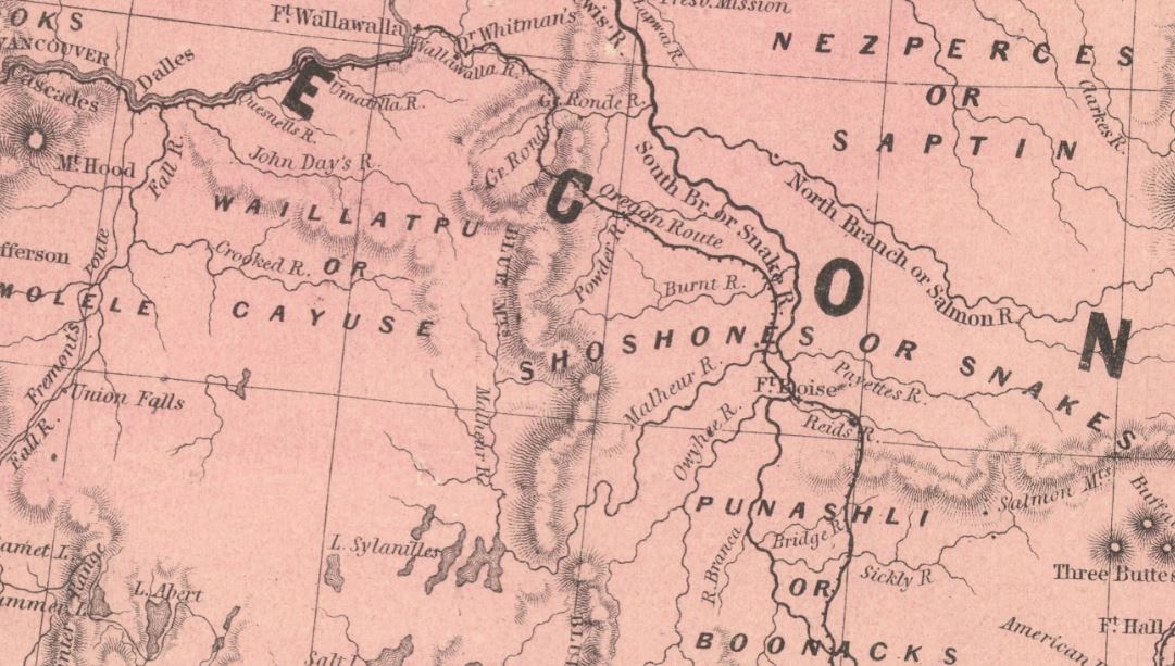
This map is also distinct in the large number of Indigenous groups it recognizes throughout each territory. Unlike other maps from this time and earlier that depict the territory of Indigenous groups as small or insignificant, the way they are labeled here indicates an acknowledgment of the true size of these groups’ land claims, such as with the Shoshone in the Oregon Territory shown above. This, paired with the apparent accuracy of the placement of the majority of these labels, provides insight into the distribution of Indigenous populations at this time and how their communities were impacted by the Treaty of Guadalupe Hidalgo.

This edition of the map also stands out from those that were made later due its large blocks of explanatory text throughout the California territory. These texts describe specific parts of the territory in great detail and were likely intended to inform the viewer about the harsher parts of the California Territory like the Great Basin. This map was published in an atlas around the start of the Gold Rush, which led to one of the largest migrations west in U.S. history across territories that were largely unexplored. Many of those who made the journey were ill-prepared and often suffered greatly and even died on the way to California, so it is possible that these texts were incorporated in an attempt to prepare travelers for the reality they would face.

The lack of Colorado River cartography makes it evident just how unexplored most of this region was in the mid-1800s. By this point in time, there had been several short expeditions up the southern portion of the Colorado from the Gulf of California which explains the relative accuracy of the southern Colorado River depicted on this map. However, as the river runs North, its path grows increasingly inaccurate and the Grand Canyon is left out altogether because it was never officially explored. It remained unexplored until the famous 1858 and 1869 expedition up the River that led to a drastic increase in knowledge of the Grand Canyon and the portion of the Colorado River that is not included on this map. The southernmost parts of modern Arizona and New Mexico are also not included in this map as they were not part of the Treaty of Guadalupe Hidalgo and would not be acquired by the United States until the Gadsden Purchase of 1853.
We hope you enjoyed this month's map! As with all of our Map of the Month features, if you’d like to learn more about this map or schedule a visit to explore our maps in person, please submit a Map and Geo Service Request. We’ll be sure to get back to you within two business days, but typically sooner.
- Kelsey Kerley, Map and GIS Assistant