One hundred and sixty one years ago, the American Civil War was raging all across the country. During the height of this conflict, The Territory of Arizona was officially established in February of 1863. Efforts to create the Arizona Territory had been ongoing since at least 1856, with a few maps showing what this new United States Territory could look like- as well as what the New Mexico Territory would be like after the split. We have a few such maps in our collection — however, for this month, we will be focusing on a very unique one. Titled Johnson’s California, Territories of New Mexico and Utah and published in 1862 by Alvin Jewett Johnson, this map is the only one in our collection to explicitly recognize the very short-lived Confederate territory of Arizona.

Previous attempts by the population of the distant southern portions of the New Mexico Territory were denied, despite their worry of the ability of the territorial government in Santa Fe to serve as an effective governmental body for the lands acquired by the Gadsden Purchase. Additional proposals were shot down in part because they were perceived as wanting to expand slavery to the southwest. 1858 would come around, with the New Mexico territorial government proposing the creation of the Arizona Territory- albeit with a north-south divider. It was not acted on, and in 1860 a delegation met in Tucson to form a provisional government along the original idea of splitting it south of the 34 degrees north latitude. In the following year, the Civil War would break out and that provisional government would successfully petition to join the Confederacy in march of 1861. It did not last long. The Union would boot the seditionists out of their Arizona territory Almost exactly a year later in 1862, with the Union officially forming the Arizona territory in 1863 using the same north-south boundary we know of today.
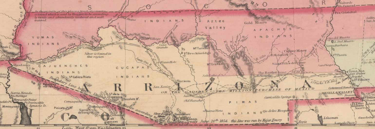
This map provides a unique look at the territorial layout of the American Southwest during the mid-19th century. The Nevada territory looks as though it’s been shrunk to half size, with Utah occupying the eastern side while the New Mexico territory greedily holds onto the land that will one day house Las Vegas. Even more curious are the labels on the northern edge of the map. The Washington territory is where modern-day Idaho presides, giving the impression that the State of Oregon is surrounded by the territory. The territory of Nebraska encompasses at least to where Wyoming would eventually preside, too.

There are also other notable geographic features that are completely absent. For instance, a vast portion of the Great Basin is completely unexplored. The entire region is very sparsely mapped — looking to be more of an artist’s imagining of the region rather than an actual map. On the other hand, there is one feature present on this map that is no more: Tulare Lake in California. Tulare Lake was drained for agricultural purposes in the late 1800s. It often reappears during periods of heavy rainfall, almost as a form of revenge against a lineage of farmers that sucked it dry. You can drain a lake, but its underlying topography will still function as a drainage basin.

We hope you enjoyed this month's map! If you'd like to see more, this map can be explored in a web application that overlays it on the modern-day United States.
As with all of our Map of the Month features, if you’d like to learn more about this map or schedule a visit to explore our maps in person, please submit a Map and Geo Service Request. We’ll be sure to get back to you within two business days, but typically sooner.
- Eric Friesenhan, Map and GIS Specialist