Map and Geospatial Hub news

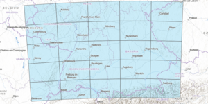
New Map Index: Southwest Germany to the Alps
Our new map series index, Southwest Germany to the Alps, is now available to the public in this interactive web map. The Southwest Germany to the Alps map series index is an interactive web map that ...

Hub Hiring Project-Based Student Worker: Dutton's Atlas (Spring/Summer 2022)
The Map and Geospatial Hub at ASU Library has a new project-based student worker position available for Spring/Summer 2022. The posting is officially listed as “Library Aide III” (job ID: 75253BR), bu...

Map of the Month: January 2022
Our January Map of the Month is this 1916 map of “The Theatre of War in Mesopotamia”, displaying Mesopotamia (modern-day Iraq and Syria) and Persia (modern-day Iran) as they appeared in the midst of W...

Map of the Month: December 2021
Our December Map of the Month is this French map titled “New Mexico, with the Northern Part of Old, Or New Spain”. Among the oldest maps in our collection, this map was made by Rigobert Bonne and was ...

Williams-Grand Canyon News: Dutton’s Atlas: How cartography helped Grand Canyon become grand
View the full Williams-Grand Canyon News article, Dutton’s Atlas: How cartography helped Grand Canyon become grand, written by Joe Giddens, and published on October 12, 2021, at the following URL: htt...

Map of the Month: November 2021
Our November Map of the Month is this illustrated map titled “Grand Canyon” by Uruguayan-American artist Jo Mora. The map depicts approximately one fourth of the Grand Canyon, focusing on the portion ...

Map of the Month: October 2021
Our October Map of the Month is this 1963 map titled “Arizona’s Lost Mines and Ghost Towns”. It features some of Arizona’s most famous lost mines and ghost towns as well as the more obscure, and it in...

Hub Hiring Two Student Workers (Fall 2021)
The Hub is Hiring! The ASU Library Map and Geospatial Hub is searching for two new student workers to join our team! Any interested students should be sure to apply by the application deadline of Oct...

ASU News: How cartography helped the Grand Canyon become grand
View the full ASU News Article, How cartography helped the Grand Canyon become grand, written by Lauren Whitby, and published on September 28, 2021, at the following URL: https://news.asu.edu/20210928...