Our December Map of the Month is this French map titled “New Mexico, with the Northern Part of Old, Or New Spain”. Among the oldest maps in our collection, this map was made by Rigobert Bonne and was published in 1780 as part of Guillaume-Thomas Raynal’s famous Atlas de Toutes Les Parties Connues du Globe Terrestre.

For the most part, this map is highly accurate for the late 1700s, providing great detail on various rivers, settlements, and missions throughout the territories. Its depiction of the Gulf Coast is especially precise given the long history of French cartography of their North American territories in this region, though it should be noted that the map’s accuracy steadily declines the further it goes into the western half of the territory.
In addition to its notable accuracy, this map depicts the new and highly impactful cartographic style of Rigobert Bonne’s maps. Bonne is known for creating some of the period’s most significant maps, most of which display a movement away from the traditional illustration and decoration seen on 17th century maps and a step toward a more detailed and pragmatic map-making. Bonne is believed to have been one of the first cartographers to use this style, and it is on clear display here. This map also bears distinctive impressions and marks from its printing process that can be faintly seen in the blank border around the map itself. Given the shape and depth of these marks (as well as the date of this map’s publication), these marks are most likely the result of the copper plates used in Intaglio printmaking.

One of the only regions of this map that is severely misrepresented is Baja California, which was common for the majority of French maps of this region in the late 1700s. Despite this, many of the islands depicted in the Gulf of California are relatively accurate in size, shape, and placement. This area of the map also includes various settlements throughout the land of the Sonoran Desert, including a few that still exist as larger towns and cities today, like Tubac, Arizona and Santa Fe, New Mexico. It also marks the locations of several well-known Indigenous populations of the region, such as the Yuma, the Maricopa, and the Apache.
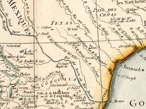
This map also depicts the area that would become the state of Texas, which was still under Spanish control at this time. Several of its settlements and rivers are marked, the most important of these rivers being the “Rio del Norte or Rio Bravo” or, as we know it best, the Rio Grande. This river has always been a crucial source of water in the region but its significance would increase drastically in 1848 when the Treaty of Guadalupe Hidalgo established the river as the international border between Mexico and Texas. In addition to rivers and settlements, there is a unique marker in the Texas territory that reads “Ici fut tue Mr. de la Salle en 1685”, which translates to “Here was killed Mr. de la Salle in 1685”. The de la Salle this marker refers to is René-Robert Cavelier Sieur de La Salle, an early French explorer who was infamously murdered by one of his own men near present-day Huntsville, Texas after an expedition turned sour.

The border of the Louisiana and Florida territories is displayed just east of the Texas territory, bordering one another along the line of the Mississippi River. At this time, Louisiana was still under French control and Florida was still owned by Spain, but in just over 20 years, Louisiana would be incorporated into the United States in the Louisiana Purchase and in about 40 years, Florida would be incorporated when the United States relinquished its claims on Spanish Texas as a trade for Florida. We can see several of the cities that were influential in the late 1700s and remain so today, such as New Orleans, Louisiana and Pensacola, Florida. Similar to the design of the Texas territory, the land of the Louisiana and Florida territories is marked with a multitude of rivers, ports, and coves, as well as the Ouacha Lake (known today as Lake Salvador).

We hope you enjoyed this month's map! As with all of our Map of the Month features, if you’d like to learn more about this map, get a scan of this map, or schedule a visit to explore our maps in person, please submit a Map and Geo Service Request. We’ll be sure to get back to you within two business days, but typically sooner.
-Kelsey Kerley, Map and GIS Assistant