Library news

'Seek and Find' exhibition opens at Fletcher Library
The exhibition, “Seek and Find” is on display at Fletcher Library on the West campus, from Jan. 9, 2023 until March 4, 2023 during regular library hours. Visitors can plan their visit at lib.asu.edu/fletcher. This is the ninth year that the ASU Library will host the creative cartography exhibition, ...

ASU Library recipients honored at 2022 President’s Awards
Arizona State University President Michael Crow honored staff and faculty members during the 2022 President’s Awards ceremony, held Dec. 8 in the Ventana Ballroom of the Memorial Union on the Tempe campus. The annual event recognizes collaborative initiatives that have demonstrated excellence in adv...

Map and Geospatial Hub 3D Explorer Wins 2022 ASU President’s Award for Innovation
On Thursday, December 8, the Map and Geospatial Hub team was awarded the 2022 ASU President’s Award for Innovation for its custom-designed, custom-built Map and Geospatial Hub 3D Explorer application. The Map and Geospatial Hub 3D Explorer is a new online tool for scaling the accessibility of libr...

Dutton’s Atlas Project Featured on KJZZ Radio
The Dutton’s Atlas project was recently featured on KJZZ’s The Show radio program. KJZZ is the local National Public Radio (NPR) affiliate station for the greater Phoenix region. Listen to project director Matthew Toro speak with The Show’s host, Mark Brodie, ab...

Labriola Blog: Native American Heritage Month 2022 Reflections
This past November, the Labriola National American Indian Data Center hosted a plethora of events for Native American Heritage Month to celebrate the diversity within our Indigenous communities and provide support and resources to American Indian students attending Arizona State University. Our e...

Map of the Month: December 2022
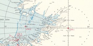
Our December Map of the Month is this 1970 map of Antarctica area stations that was prepared for the 1969 expedition of the U.S. Navy Operation Deep Freeze called “Deep Freeze 70”. It is a complete map of the Antarctic continent that features extensive detail on the locations of all operating and re...

Research data stewardship is for everyone
Renée Palting, Research Data Intern The 2023 National Institute of Health (NIH) Data Sharing Policy and requirements have generated great discussions on how the policy will impact researchers and what they should expect. Whether or not you are currently receiving NIH funding, you should be aware t...

Seek and Find: creative cartography exhibition at Noble Library
In its ninth year, Noble Library will host the creative cartography exhibition, a collaboration between the ASU School of Art and the ASU Library. The 2022 exhibit, “Seek and Find” is on display at Noble Library on the Tempe campus, from Nov. 16 until Nov. 29 during regular library hours. Visitors c...

Map of the Month: November 2022
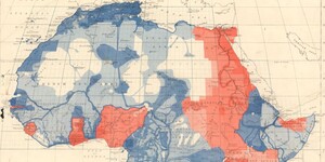
Our November Map of the Month is this 1919 British War Office map titled “Map of Africa to Illustrate the Progress of Surveys and Explorations”. Originally published in 1914 and updated in this edition, it depicts the entirety of the African continent with data on the topographic surveys that had be...