Our March Map of the Month is this historic 1897 "Map of Cuba” published by an American company during the Cuban War of Independence, mere months before the start of the Spanish-American War. It portrays the various provinces, towns, and railroads of Cuba as well as its surrounding islands and close proximity to the United States.

This map was originally accompanied by a booklet titled “Map and History of Cuba: Including a Clear and Graphic Account of the War of 1895-1897” that detailed information about the ongoing Cuban War of Independence in an attempt to sate American interest on the subject. The American public of the late 1800s often found their interests drawn to foreign affairs as a result of their increasing economic involvement with other nations or because of the rampant yellow journalism that resulted in highly dramatized news stories. In the case of Cuba, it was a mix of both.
After abolishing slavery, Cuba experienced massive changes to its economic and class systems that led to new trade developments with the United States and an overall increase of American capital flowing in and out of the country. As a result, when middle and low class Cubans went to war for independence from Spain, the United States had a vested interest in the war’s outcome. This economic interest quickly evolved into socio-political interest as journalists put a humanitarian, dramatized spin on their stories about Spanish brutality in Cuba and as U.S. politicians began considering making an attempt to assimilate Cuba if Spain relinquished it.

Although the U.S. was neutral in the Independence War through the early years, it still maintained its trade connections with Cuba despite the riots and fighting across the island. In early 1898, a few months after this map’s publication, the U.S.S. Maine was sent to Havana on a mission to protect U.S. interests in the city during a series of riots. While anchored in Havana Harbor, an explosion rocked the ship and it sank, killing over 200 crew members. The source of the explosion was never determined, but U.S. politicians and journalists were quick to claim that Spain had attacked a neutral ship, effectively whipping the American public into a frenzy for vengeance and leading to the start of the Spanish-American War in April of 1898.
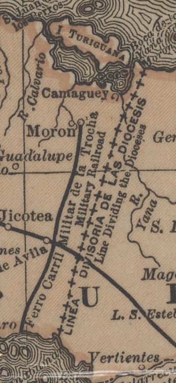
Because this map was published prior to the start of the Spanish-American War, it provides insight into what information the United States had about the situation in Cuba at the time and reveals a few surprising insights. One of the most prominent of these is the depiction of a military railroad in the middle of the island that was likely used for transporting military forces and supplies to combat the revolutionaries. In addition to indicating a region that was likely a military stronghold, this depiction also indicates that the United States had knowledge of Spanish-Cuban military movements and actions to some extent. Perhaps this information was collected in the name of protecting American economic interests (as with the mission of the U.S.S. Maine) or maybe it was even in response to Congressional arguments in favor of U.S involvement with the intention of assimilating Cuba. The map also includes other local administrative features, such as the line dividing the church diocese in the center of the island.

We hope you enjoyed this month's map! As with all of our Map of the Month features, if you’d like to learn more about this map, get a scan of this map, or schedule a visit to explore our maps in person, please submit a Map and Geo Service Request. We’ll be sure to get back to you within two business days, but typically sooner.
- Kelsey Kerley, Map and GIS Assistant