Our June Map of the Month is a 1905 “Map of the Denver & Rio Grande System” depicting the extent of the Denver and Rio Grande Railroad at the time as well as its connecting lines and variation in rail type throughout the system. The Denver and Rio Grande was one of the largest and most significant railroads in American history and was best known for its narrow gauge lines that helped in traversing the tricky landscape of the Rocky Mountains.
The Denver and Rio Grande System operated from 1870 to 1992 and was at its most expansive in 1917 when it comprised close to 6,000 miles of track. This map is one of many from the early 1900s that display the railroad’s span and when compared to one another, the slow but steady expansion of the lines throughout the years is apparent. When originally established by General William Jackson Palmer, the Denver and Rio Grande System was primarily intended to simply run South of Denver to the Rio Grande. However, due to competition from another railroad, new mines opening in Utah, and the advice of Palmer's business partner William Bell, the idea was evolved to create a ‘bridge line’ between Denver and Salt Lake City that ran through dozens of new mining towns. While it did run passenger trains, the railroad’s main purpose was to transport freight like coal, gold, and silver out from the Rocky Mountain mines. This required the trains to be able to weave around the steep walls and tight corners of the Rockies, leading Palmer to use narrow gauge track for a large portion of the railroad.
Narrow gauge track only has a width of about three feet compared to the much wider standard gauge that averages five feet in width. This narrow gauge rail lent itself to the terrain of the Rocky Mountains more than standard gauge and was often less expensive to install, which also contributed to Palmer’s choice to start the system with narrow gauge rail. As the railroad expanded, standard gauge rail was used more frequently, but a large portion of the system maintained the use of narrow gauge rail, especially the lines that were in the heart of the Rocky Mountains. These different gauges are denoted clearly on this map, highlighting how much of the system was made up of narrow gauge rail. By 1889, the Denver and Rio Grande Railroad was the largest narrow gauge network in North America, and it quickly became a favored railroad for the speed and skill with which the trains navigated the terrain.
The Denver and Rio Grande railroad operated independently until 1992, at which point it was consolidated with the larger and increasingly successful Southern Pacific Railroad. Both railroads were eventually sold to the Union Pacific Railroad in 1996 and the most distinctive elements of the Denver and Rio Grande trains were removed or altered to fit Union Pacific branding. Although the most recognizable features of the Denver and Rio Grande system are gone, several of its smaller lines are privately owned and are still in operation as heritage railways. One of the most well-known and unique of these lines is the Durango and Silverton Railroad located in southwest Colorado. One other section still exists, now operating as the Cumbres and Toltec.

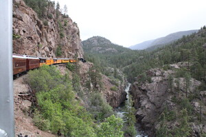
Renowned as one of the tourism highlights of Colorado, the Durango and Silverton Railroad connects the small city of Durango to Silverton, a historic mining town that was originally incorporated into the Denver and Rio Grande System due to the abundant silver and gold deposits nearby. This line has forgone its history of running freight trains for running passenger train day trips up and back from Silverton. The line is known for its beautiful views of the Rocky Mountains and the Animas River as well as the narrow gauge track it uses to smoothly cut through the mountains.
We hope you enjoyed this month's map! As with all of our Map of the Month features, if you’d like to learn more about this map or schedule a visit to explore our maps in person, please submit a Map and Geo Service Request. We’ll be sure to get back to you within two business days, but typically sooner.
-Kelsey Kerley, Map and GIS Assistant


