Our March 2021 Map of the Month is this 1897 Pilot Chart of the Great Lakes by J.E. Craig and A.C. Roberts. It includes a detailed navigational map of the lakes as well as a variety of information on boating etiquette, weather signals, and other useful notes for sailing on the Great Lakes.

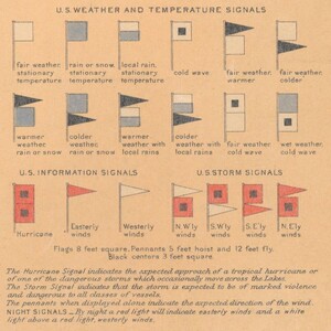
The front of the map shows a highly accurate rendering of the lakes accompanied by multiple compass roses that are angled to match the Earth’s curvature toward the northernmost reaches of the lakes. It has passages explaining how to use the chart to navigate, tables of the frequency of fog based on location, a key of American and Canadian weather signals that may be used on the lakes, and information about the different docks and canals in the region.

The Great Lakes have long been notorious for their immense size and dangerous weather patterns, both of which have contributed to the loss of thousands of ships over the last three centuries. Pilot charts like this one were used by sailors to chart their ship’s true course (relative to latitude lines) and compass course (relative to the ship’s compass) and plan their journeys based on the information provided in the hopes of safe passage.

The reverse of this map displays an impressive table that provides the distance between different locations throughout the Great Lakes. It also contains a long passage on the “Rules of the Road for the Great Lakes” as set forth by the United States Congress.

Despite being published by the United States Navy, there is no record of the existence of this particular map in any government or publication database. There is not even a record of its production from the lithography company that printed it, so much of the history of the map and the process of its creation remain unknown.
Although this map is over 100 years old, its depiction of the coastlines of the Great Lakes is very similar to modern satellite imagery and many of the features it denotes, including the hundreds of lighthouses (marked by small red flames), are still present today.

We hope you enjoyed this month's map! As with all of our Map of the Month features, if you’d like to learn more about this map or schedule a visit to explore our maps in person, please submit a Map and Geo Service Request. We’ll be sure to get back to you within two business days, but typically sooner.
- Kelsey Kerley, Map and GIS Assistant