Our April Map of the Month is titled “Carte de la Californie” and compares five recreations of historically significant maps of California to show the evolution of cartographic knowledge of the region. It was originally published as a supplemental material to Diderot’s Encyclopédie, and this particular copy is believed to have been published circa 1770.

The first edition of Diderot’s Encyclopédie was published in 1751 and he went on to publish over 20 additional volumes throughout the next 26 years. Encyclopédie was a product of the French Enlightenment, with his main goal in publishing it being to provide the French people with a means to educate themselves about as much of the world as possible. It is widely considered one of the most influential works of the 18th century. Like most encyclopedias, Diderot’s Encyclopédie contained information on a vast variety of subjects, including exploratory history, geography, and cartography, which “Carte de la Californie” was likely created to supplement.

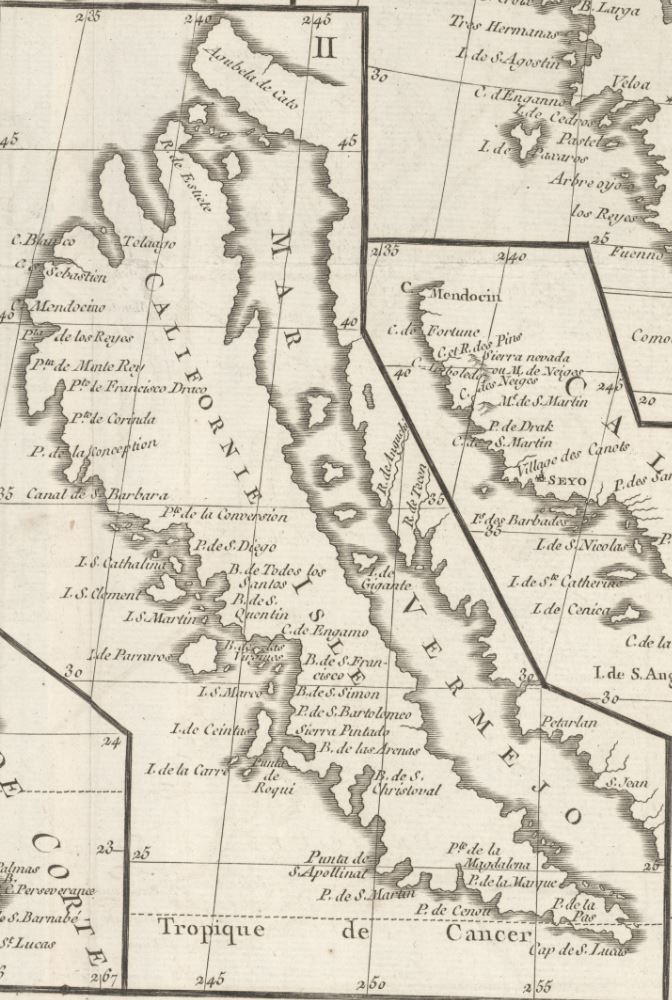
This map shows side-by-side views of five historic depictions of the Southern California coast that were all considered the most accurate map of the region at different points in history. The map excerpts are numbered and are identified in the map’s key as follows:
Map I. Mathieu Néron Pecci’s 1604 “Manuscript Map of America”.
Map II. Nicolas Sanson’s 1656 “Map of Florida and New Mexico (California as Island)”.
Map III. Guillaume De L'Isles’ 1700 “Map of America”.
Map IV. Father Eusebio Kino's 1705 “Passage By Land To California”.
Map V. The Society of Jesuits’ 1767 “California and New Mexico” as published by Isaak Tirion.
The organization of this map makes the progression of cartographic knowledge on California very clear as the coastline and Baja Peninsula transition from jutting, ragged landscapes into increasingly accurate representations that are more similar to the California we know today.
Some of the maps shown in this conglomeration are strikingly inaccurate and are evidence for how little knowledge the French population had of California in the 1600s. The best example of this is Map II by the French Royal Geographer Nicolas Sanson which depicts California as an island rather than being on the West Coast of North America. While humorous in the present, this map was actually the product of a surprisingly common rumor about the New World that was circulating France in the mid-1600s and perpetuating the myth that California was in fact an island. Map III shows that this rumor was eventually dispelled, but for a time, it was held as truth by many, including educated and accomplished individuals like Sanson.

The latest and arguably most accurate map included on the “Carte de la Californie” is Map V, created by The Society of Jesuits in 1767 and popularized by publisher Isaak Tirion. It is the most detailed map shown here and denotes details such as Jesuit missions, Indigenous groups, mountain ranges, and several settlements and towns. At the time of this supplement’s publication, this map was considered the most accurate and widely used in France and is now considered one of the best maps of California from the late 1700s. As a whole, “Carte de la Californie'' is an invaluable piece of cartographic history that provides great insight into not only the evolution of European cartographic knowledge of California but also the rising interest in accessing knowledge of any kind that developed during the French Enlightenment.
We hope you enjoyed this month's map! As with all of our Map of the Month features, if you’d like to learn more about this map or schedule a visit to explore our maps in person, please submit a Map and Geo Service Request. We’ll be sure to get back to you within two business days, but typically sooner.
- Kelsey Kerley, Map and GIS Assistant