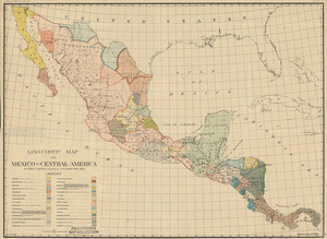
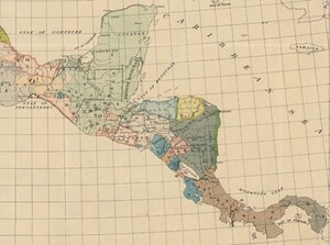
Our April Map of the Month is this 1909 Linguistic Map of Mexico and Central America by Cyrus Thomas and J.R. Swanton. It displays the geographic distribution of a variety of Mesoamerican languages and dialects throughout Mexico and Central America.

Mesoamerica is one of few regions in the world where some of the language families that developed without outside influence survived colonialism, making them unique and important indicators of historical populations and cultural development. This map was produced by the Bureau of American Ethnology to identify which of these languages and dialects were prominent among different populations.

Some of the largest language families cover entire regions, such as Nahuatlan (descended from/related to the language of the Aztecs) spanning across much of Northern Mexico or Mayan comprising the entire Yucatan Peninsula. Other dialects are confined to portions of regions, like the small patch of Matagalpan speakers in Nicaragua and the tiny coastal population of Huavean speakers on the Gulf of Tehuantepec.

Throughout the several centuries of Spanish occupation, native people were expected to assimilate by learning Spanish, so Indigenous languages like those documented on this map were stifled by the government and many died out entirely as a result. It was not until the early 20th century that a more positive perception of Indigenous culture developed, leading many people to learn the languages their parents had been prohibited or discouraged from teaching them. This increase in speakers and attempt to reclaim lost cultures continued through the century, supported by the Mexican Revolution, and allowed for the millions who speak Indigenous languages in the region today.
Since the creation of this map over 100 years ago, several of the documented languages and dialects have gone extinct or are on the verge of extinction, including Lencan and Matagalpan (Northern Central America), Pakawan (Northeastern Mexico), and Waïcurian (Southern Baja Peninsula). The governments of Mexico and the Central American nations have created initiatives to teach many languages nearing extinction to non-speakers and many independent organizations are also working to keep these languages alive.

We hope you enjoyed this look at April’s Map of the Month! If you would like to get a high resolution scan of the map or schedule an appointment to explore the collection in person, please submit a service request to the Map and Geospatial Hub.
-Kelsey Kerley, Map and GIS Assistant