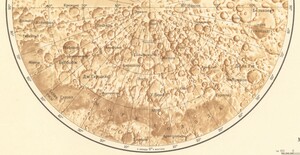
Our July Map of the Month is this 1967 Soviet lunar map from the series titled Polnaya Karta Luny Complete Map of the Moon. The series is made up of nine sheets that display several magnified lunar quadrant maps, translations of the labels throughout the series, and this final composite lunar pole map. It depicts the moon’s north polar region (left) and south polar region (right) including the names of many of the most prominent craters and other features. It also provides a variety of statistics about the moon and its relation to the Earth as well as the details of six lunar missions that contributed to the creation of this map.

The illustrations of the polar regions on this map were compiled using photographs taken during previous Soviet lunar missions as well as other images of the moon’s surface from Earth collected by Moscow’s Sternberg Astronomical Institute. The resulting illustrations are both highly detailed and accurate even when compared with more recent satellite imagery and lunar mapping. The large blank areas that appear on this map are a result of there being little imagery of the far or “dark” side of the moon at this time, so the only lunar features depicted are those on the near side of the moon.

This sheet from the Polnaya Karta Luny series includes thousands of lunar craters and shows where and how many of them overlap and supersede each other, which provides insight into the relative ages of each impact site. Many of the moon’s largest and oldest craters are labelled, including Babbage Crater (Беббидж), J. Herschel Crater (Дж. Гершель), De la Rue Crater (Де ла Рю), and Endymion Crater (Эндимион). It also depicts portions of multiple lunar maria such as the Mare Humboldtianum (Море Гумбольдта) and Mare Frigoris (Море Холода).

In addition to its illustrations of the moon’s topographic features, Polnaya Karta Luny also lists many important statistics about the moon and its relationship to Earth. The statistics on this sheet include the average distance between the moon and the Earth (recorded as 384,400 km), the moon’s orbital period (recorded as 27.3217 average days), and the percentage of the moon’s surface that had been observed from Earth (estimated at 59% of the lunar surface area). There are also a few statistics describing the surface conditions of the moon, such as the most extreme temperatures documented at a given time (130℃ in daytime and -150℃ at night). The statistics that dealt with surface conditions were likely considered the most valuable when this map was created due to the Soviet Union’s fierce competition with the United States to be the first to land a manned mission on the moon’s surface.

This competition between the U.S.S.R. and the U.S. stemmed from Cold War tensions as both superpowers struggled to outdo one another in every way, including space exploration. The Space Race comprised decades of scientific innovation and dozens of missions on both sides (including the Luna and Zond programs that provided the knowledge for this map). It reached peak competitiveness during the late 1960s, and on July 20, 1969 the United States’ Apollo 11 mission successfully landed on and returned from the moon, marking what many consider the end of the Space Race.
We hope you enjoyed our July Map of the Month! If you would like to get a high resolution scan of this map series or schedule an appointment to explore the collection in person, please submit a service request to the Map and Geospatial Hub.
-Kelsey Kerley, Map and GIS Assistant